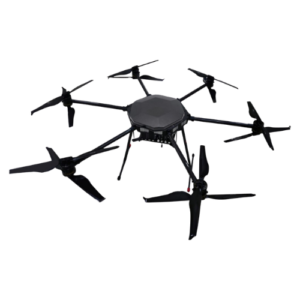
The Q6 drone, also known as the ideaForge Q6 drone, is a high-performance mapping UAV designed for professionals who require precision, efficiency, and ease of operation. This UAV belongs to ideaForge’s small-category segment and offers excellent flexibility compared to hybrid drones.
With its advanced quadcopter design and capability to cover large areas, the Q6 enables users to complete large-scale mapping and surveying projects efficiently without compromising data quality. Flight planning, reduced piloting effort, and high-precision data output are simplified through the integrated BlueFire Ground Control Station (GCS), making it an ideal tool for GIS professionals, surveyors, and infrastructure planners.
Key Features of Q6 Drone
- Made from High Strength Carbon Fiber
- Powerful Smart Battery for Maximum Endurance
- Carbon fibre propellers for maximum thrust-to-weight ratio
- 5 cm or Better – Ground Sampling Distance (GSD)
- Operational Range – Up to 5 km
- Flight Time – Up to 50 min
- Take-off Weight – Less than 6 kg
- Area Cover Per Flight at 120 m AGL – Up to 1.75 Sq km
- <10 cm – Absolute X, Y Accuracy at 120 m AGL in Real-world condition
- <20 cm – Absolute Z Accuracy at 120 m AGL in Real-world conditions
- Typical Cruise Speed – 10 m/s
- Functional Temperature Range – 0°C to +50°C
Payload
The conceptForge Q6 drones specifications entail a robust mapping weight combined with a survey-grade PKK module, which guarantees high-precision and trustworthy precision in its category.
- Imaging Camera 20 MP HD
- Survey-grade PPK Module
- Ground Sampling Distance (GSD) 5 cm or better
- Absolute X, Y Accuracy <10 cm at 120 AGL in real-world conditions
Ground Control Station
The conceptForge Q6 drones specifications entail a robust mapping weight combined with a survey-grade PKK module, which guarantees high-precision and trustworthy precision in its category.
- Pre-flight Checks
- Predefined Flight Paths
- Waypoint based navigation
- Take-off & Landing Assist
- Drone Health Monitoring
Technical ideaForge Q6 Drone Specifications
| Category |
Specifications |
| Aerial Vehicle (AV) Characteristics |
- UAV Weight with battery and max. payload: <6 Kg
- Range of live transmission (LOS): 5 km (un-obstructed & interference free)
- Typical Cruise Speed: 10 m/s
- Functional Temperature Range: 0°C to +50°C (OEM Certification)
- Dust & Drizzle Resistance: IP53 rating (OEM Certification)
- Deployment Time: <10 minutes
- Packaging and Storage: Waterproof Backpacks to carry all mission critical components
- Regulatory Compliance: NPNT Ready – applicable for Indian airspace
|
| Base Station Characteristics |
- GNSS Grade: High accuracy L1 & L2 Frequency Band Enable PPK
|
| Mapping Performance at 120m AGL |
- Ground Sampling Distance (GSD): 5 cm or Better
- Absolute X, Y accuracy: <10 cm at 120 m AGL (with 95% confidence interval)
- Absolute Z accuracy: <20 cm at 120 m AGL (with 95% confidence interval)
|
| Ground Control Station (GCS) Software Features |
- Terrain Avoidance: Detects and avoids natural terrain by using elevation data (where available)
- Geo Tagging
|
| Communication link Characteristics |
- Autonomous Flight Termination System or Return Home (RH) option: Return and avoids natural terrain by using elevation data (where available)
|
| Failsafe Features |
- Multiple GPS on-board: For Redundancy
- Auto-Return to Home and Land: On Communication Failure
- Auto-Return to Home and Land: On Low Battery
- Auto-Return to Home and Land: On exceeding Wind limit of the system
- Auto-Return to Home and Land: On Battery Imbalance
- Auto-Return to Home and Land: On exceeding Temperature limit of the system
|
| Warranty |
12 months or 500 flights whichever is earlier. |
Features
- SOI Qualified Small Drone – Passed technical qualifications for Survey of India (SOI) for Swamitva Yojna
- Terrain Avoidance & Fail-safe Coverage – Safely conduct surveying operations in tough weather and terrain conditions
- Quadcopter Configuration with VTOL – Conduct mapping operations with greater flexibility
- Manual Mode – Take control when needed
- Superior Accuracy – <5 cm in X & Y – axis and <20 cm in Z – axis with survey grade PPK Module
- Less than 10 minutes Deployment Time – User-friendly assembly to conduct mapping operations faster
- Robust Build Quality – Map up to 3500 sq. km with a single Q6 UAV
- Minimal Training Requirements – No UAOP, Security Clearance, or DGCA Training required* (*applicable in India only)
- Best-in-Class Area Coverage – Fly longer and farther for higher ROI per flight
- Pause & Restart – Conduct mapping operations with greater flexibility
- Take-off in Higher Winds – Over 40% Better Takeoff Stability as compared to Hybrids, minimizing your days wasted
- NPNT Ready – Ready for India’s Drone regulations
Applications of Q6 Drone
With its industry-leading hardware and micro category weight, Q6 Mapping UAV delivers unbeatable area coverage with centimeter level accuracy, no matter your experience.
- Highway Network Expansion
- Disaster Preparedness
- Land Surveying
- Mining Site Planning
- Urban Planning
- Railway Network Expansion
FAQS
1. What is the Q6 drone used for?
The Q6 drone, which is also called ideaForge Q6 drone, is mostly utilized in high-precision mapping and surveying tasks. It is common in such industries as land surveying, urban planning, mining, and infrastructure development. Having a sophisticated quadcopter structure and survey-level precision, the drone Q6 allows professionals to retrieve geospatial information effectively even in adverse conditions.
2. What are the key specifications of the ideaForge Q6 drone?
The specifications of the Forge Q6 drone are as follows: it has a flight duration of up to 50 minutes, a range of up to 5 km, as well as a weight of less than 6 kg. It has Ground Sampling Distance (GSD) of 5 cm or higher and is provided with a 20 MP camera and PKK module that is very accurate. The drone has autonomous flight as well through a Ground Control Station.
3. How accurate is the Q6 mapping UAV?
Q6 drone provides survey grade accuracy with inbuilt PKK module. It offers absolute accuracy of not more than 10cm in X and Y and less than 20cm in Z axis at 120 m AGL.Such accuracy is what allows making the drone Q6 suitable in GIS mapping, infrastructural planning, and in-depth land surveying.
4. What makes the Q6 drone suitable for large-scale mapping projects?
The Q6 drone is offered to be used in large-scale mapping because of the long-flight-time, high-area-coverage, and auto-flight options. It is suitable in large area projects since it can cover as much as 1.75 sq. km per flight and it can as well take as long as 50 minutes. Its efficient flight planning through GCS and strong construction are used to assure the completion of the project faster with less manual interference.
5. Is the ideaForge Q6 drone compliant with Indian drone regulations?
Yes, the Q6 drone will be NPNT (No Permission, No Takeoff) compliant and will be in line with Indian regulations of drones. The ideaForge Q6 drone is also aimed to comply with operational standards needed to be used as a professional drone in India. It also needs very little training and is safe to work with, with numerous fail-safe capabilities, such as automated return-to-home mode.

")